Why Skip the Crowds This Year
California’s iconic parks like Yosemite, Big Sur, and Lake Tahoe rightfully get a lot of love, but they also get the crowds to match. In 2026, more backpackers are searching for solitude, not switchbacks packed with tourists.
The Shift Toward Quieter Trails
Many hikers are rethinking their go to routes and opting for the road less traveled. Why?
Smaller crowds mean you can pace yourself, enjoy nature uninterrupted, and camp without competition.
Better wildlife sightings fewer people means more chances to spot deer, bears, or even a golden eagle.
Reduced stress around permits some of these hidden gems don’t require advance bookings or have looser quota systems.
High Reward, Low Foot Traffic
Choosing an underrated trail doesn’t mean sacrificing views or experience. In fact, many of California’s lesser known trails deliver just as much payoff:
Crystal clear alpine lakes without a dozen people jumping in
Granite peaks that rival the high Sierra, minus the backpacker traffic
Remote meadows blooming with untouched wildflowers
If you know where to look, you can find deeply rewarding backpacking routes that offer true backcountry silence and still be back in time for work on Monday.
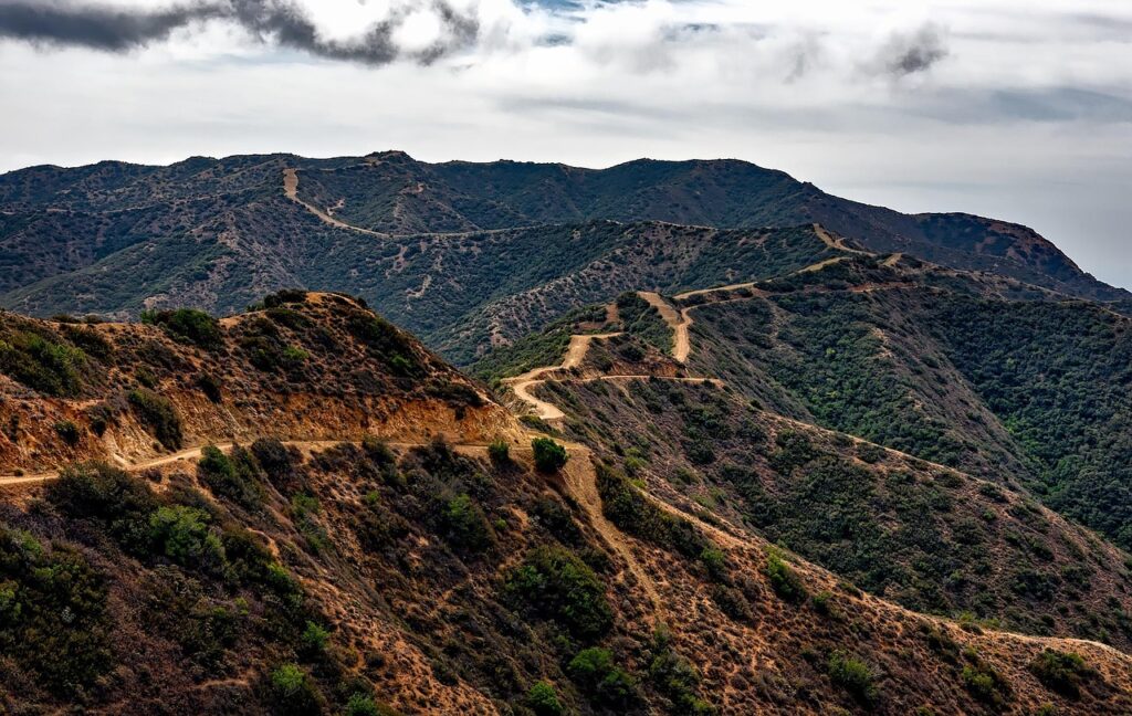
Caribou Lakes Loop (Trinity Alps)
If you’ve ever looked at the Sierra and thought, “What else is out there?”, Caribou Lakes Loop is your answer. This 18 mile loop in Northern California’s Trinity Alps offers the kind of rugged, granite strewn scenery that rivals anything in Yosemite without the elbow to elbow trail crowds.
The route winds through wildflower meadows, skirts a series of crystalline alpine lakes, and offers front row views of towering cliffs that feel untouched. It’s moderate in difficulty, but don’t mistake that for boring it’s the kind of backpack where each bend in the trail delivers a fresh jaw drop.
Best part? You’re unlikely to see more than a handful of hikers. There’s zero cell signal, zero development, and total immersion in big, quiet country. Nights here aren’t just dark they’re starlit in full theater, quiet enough to hear your own heartbeat.
Unlike most Sierra routes, there’s no permit quota to wrestle with. Just pack it in, leave no trace, and soak up the solitude. This is what backpacking looked like before everything got booked out months ahead. Welcome back.
Bear Basin Trail (John Muir Wilderness)
A Quiet Detour off Bishop Pass
Just a short branch off the heavily trafficked Bishop Pass route, Bear Basin Trail offers a wildly underrated escape into deep wilderness. While most hikers continue along the main corridor, this side trail remains virtually untouched.
Located within the stunning John Muir Wilderness
Accessed from Bishop Pass, but veers toward solitude quickly
Minimal signage and foot traffic keep it remote
What You’ll See
The real reward lies in the pristine beauty and untamed environment. You won’t find established campgrounds or steady footpaths here just the kind of raw nature that defines true backpacking adventures.
Crystal clear alpine creeks and meadows filled with wildflowers
Hidden lake basins that require light off trail navigation
Occasional bear sightings bring your canister and stay alert
Ideal Hiking Season
To truly enjoy Bear Basin Trail, timing is everything.
Best time: Late summer (mid August through early September)
Snow has usually melted, but crowds remain distant
Wildflowers linger, and skies are typically clear
Want More Like This?
If remote alpine lakes and under visited basins are what you seek, check out Secret Alpine Lakes Worth the Hike in the Sierra Nevadas for more hidden gems north and south of the John Muir Corridor.
Lost Coast Trail Northern Section
Most people hit the southern part of the Lost Coast and call it a day. Fewer venture north and that’s exactly why it’s worth it. This stretch pulls no punches: it’s steeper, wilder, and more demanding. Think narrow footpaths carved into fern draped cliffs, ocean mist in your face, and almost no one else in sight.
Waves smash against black sand beaches while you navigate up and over rugged ridgelines. Solitude’s a given. So is the risk. This trail doesn’t care if you’re late miss the low tide window and you’ll be trapped between rock walls and rising water. Prepping tide charts is non negotiable.
This leg isn’t for beginners. You’ll need strong legs, a good weather window, and flawless timing. But for coastal vets looking for silence, sea lions, and a serious challenge, there’s nothing else in California quite like it.
Kennedy Lake via Deadman Canyon (Emigrant Wilderness)
This one hides in plain sight just north of Yosemite, but rarely touched. Kennedy Lake sits in a granite basin at the end of a quiet trail that veers off from the main Kennedy Meadows route. What you get: wide open alpine beauty, cold river crossings, and ghostly remnants of old cattle camps. It’s as if someone hit pause on the world back here.
The trail cuts through meadows and along ridgelines before dropping into Deadman Canyon. It’s not grueling, but it’s long enough to keep the casual day trippers out. That’s the draw. Backpackers looking for solitude without bushwhacking through trail less nothing will find just the right balance here.
Because it’s outside the Yosemite quota zones, permits are easier. Great for a low planning long weekend or a quiet overnight with no cell bars, no crowd chatter just wind, granite, and space to breathe.
Cuyama Peak to Figueroa Mountain (Los Padres National Forest)
A Hidden Southern California Ridge Line
Tucked deep in the Los Padres National Forest, the Cuyama Peak to Figueroa Mountain route remains one of the most overlooked backpacking experiences in Southern California. For those who crave remote ridges, seasonal beauty, and minimal crowds, this stretch delivers if you’re prepared.
Highlights Along the Trail
Wildflower Season: Each spring, this trail erupts in vibrant bloom, rivaling the more famous California super blooms.
Year Round Views: Sweeping vistas of the Cuyama and Santa Ynez Valleys are a constant reward, even outside bloom windows.
Epic Ridgetop Hiking: The route follows a rugged, elevated spine offering dramatic drops and distant views.
Know Before You Go
Distance & Terrain: Over 20 miles of exposed ridgetop hiking make this trail both rewarding and demanding.
Water Scarcity: Water is scarce along the route plan ahead and carry all you’ll need.
When to Hike: Best completed between October and April to avoid extreme summer heat.
Who It’s For
This trail is ideal for:
Experienced backpackers with solid navigation skills
Southern California locals seeking solitude without driving north
Spring hikers chasing spectacular wildflower shows
This is not a crowded trailhead or a first timer’s playground, but for self sufficient adventurers, Cuyama to Figueroa is a hidden gem worth every dusty step.
Trail Tips for 2026
Exploring underrated backpacking trails often means heading into more remote, less managed environments. Preparation and awareness are key if you want to enjoy the trail and stay safe.
Stay Ahead of Wildfire Risks
Wildfires are becoming a year round threat in California.
Always check real time fire conditions and forest service alerts before you hit the trail
Be ready to pivot: closures and fire behavior can change overnight
Avoid fire prone zones during peak heat and wind conditions
Leave No Trace = Survival Skill
In fragile, lesser traveled areas, your impact matters even more.
Stick to durable surfaces and avoid cutting switchbacks
Pack out every scrap yes, even food waste and biodegradable items
Camp at least 200 feet from lakes and streams to protect water sources
These aren’t just ethical choices they help prevent environmental damage that leads to more trail closures and fire risks.
Map Smarter, Not Just Harder
Cell service is rare or nonexistent on most of these trails. Don’t rely on hope and battery life.
Bring downloaded GPS maps (Gaia, CalTopo, AllTrails Pro options work well)
Always carry a backup paper topo map for worst case scenarios
Know how to use a compass or hike with someone who does
Being prepared means spending less time lost, and more time soaking up California’s secret wild spaces.
 There is a specific skill involved in explaining something clearly — one that is completely separate from actually knowing the subject. Robertong Stanleyer has both. They has spent years working with trail prep and packing tips in a hands-on capacity, and an equal amount of time figuring out how to translate that experience into writing that people with different backgrounds can actually absorb and use.
Robertong tends to approach complex subjects — Trail Prep and Packing Tips, Hidden Gems, Outdoor Exploration Basics being good examples — by starting with what the reader already knows, then building outward from there rather than dropping them in the deep end. It sounds like a small thing. In practice it makes a significant difference in whether someone finishes the article or abandons it halfway through. They is also good at knowing when to stop — a surprisingly underrated skill. Some writers bury useful information under so many caveats and qualifications that the point disappears. Robertong knows where the point is and gets there without too many detours.
The practical effect of all this is that people who read Robertong's work tend to come away actually capable of doing something with it. Not just vaguely informed — actually capable. For a writer working in trail prep and packing tips, that is probably the best possible outcome, and it's the standard Robertong holds they's own work to.
There is a specific skill involved in explaining something clearly — one that is completely separate from actually knowing the subject. Robertong Stanleyer has both. They has spent years working with trail prep and packing tips in a hands-on capacity, and an equal amount of time figuring out how to translate that experience into writing that people with different backgrounds can actually absorb and use.
Robertong tends to approach complex subjects — Trail Prep and Packing Tips, Hidden Gems, Outdoor Exploration Basics being good examples — by starting with what the reader already knows, then building outward from there rather than dropping them in the deep end. It sounds like a small thing. In practice it makes a significant difference in whether someone finishes the article or abandons it halfway through. They is also good at knowing when to stop — a surprisingly underrated skill. Some writers bury useful information under so many caveats and qualifications that the point disappears. Robertong knows where the point is and gets there without too many detours.
The practical effect of all this is that people who read Robertong's work tend to come away actually capable of doing something with it. Not just vaguely informed — actually capable. For a writer working in trail prep and packing tips, that is probably the best possible outcome, and it's the standard Robertong holds they's own work to.