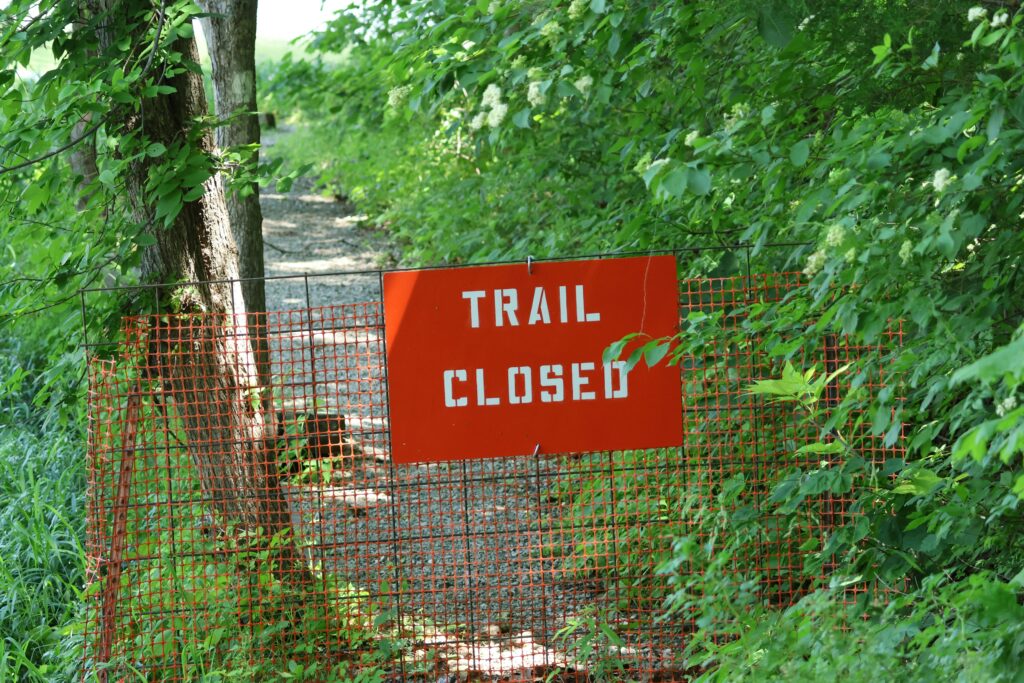
What’s Actually Causing Trail Closures in 2026
Trail closures aren’t sudden. They’re the result of pressure climatic, human, and administrative that’s been building for years. In 2026, that pressure has hit a tipping point.
First, the climate. Wildfires are popping up earlier, burning hotter, and sticking around longer. Downpours that used to be seasonal are now flash flooding fragile terrain. Landslides are following close behind. Trails once open year round are now closed without warning as conditions turn dangerous fast.
Then there’s overuse. Some trails have become social media hotspots, drawing crowds not built for wilderness ethics. That means more litter, deeper ruts, and badly eroded switchbacks. Trail crews can’t keep up. Many routes are shutting down simply to recover.
Agencies are also stepping in not just for repair, but to protect. Conservation closures aren’t always about damage; sometimes, they’re preemptive. A threatened species moving through. A meadow that needs to reseed. In those cases, access gives way to ecology.
Finally, the seasons are shifting. Snowmelt happens later, peak heat hits earlier, and the old calendar doesn’t hold. Some summer trails won’t open until mid July. Others could close well before Labor Day. If you’re still planning your hikes around historic dates, you’re already behind.
Staying on the trail in 2026 isn’t just about fitness it’s about awareness. Less guesswork. More prep.
Why It’s a Bigger Deal Than You Think
Trail closures might seem like a minor inconvenience until you’re standing at a gated trailhead after driving for hours. In 2026, the stakes are higher than ever as closures affect more than just weekend plans.
When Access is Denied, Plans (and Safety) Can Spiral
Getting turned away from a planned trail:
Disrupts travel timelines and can add unexpected costs
Forces detours that impact lodging, food, and fueling needs
Leaves hikers scrambling for alternatives they may not be equipped for
For backcountry hikers, that disruption can be more than frustrating it can lead to risky decisions made under time pressure.
Rerouting Isn’t Always Simple or Safe
Emergency rerouting due to a closure often involves last minute navigation of unfamiliar terrain. This can introduce new hazards, such as:
Poor cell service or outdated maps
Lack of water sources on alternate routes
Less maintained or more technical trails
When trails close without warning, hikers need to be ready to pivot quickly and responsibly.
Closures Point to Bigger Problems
Many closures are not random they’re signals. Understanding why a trail is off limits can give insight into the health of the landscape:
Post wildfire recovery: Burn scars need time to stabilize before hikers return
Erosion and overuse: Heavily trafficked trails may be suffering from severe ecological wear
Wildlife protection: Sensitive breeding or migration periods may require temporary closures for endangered species
In short, closures are not just about keeping people out they’re about giving nature space to heal. Recognizing that can shift how we react and adapt as hikers.
How to Stay Ahead of the Curve
Trail closures don’t have to leave you scrambling. With the right tools and knowledge, you can stay informed and make smart, flexible plans before heading out. Here’s how prepared hikers are staying ahead in 2026:
Know Where to Look: Real Time Trail Access Tools
Stay current with closures, reroutes, and safety alerts by using platforms designed for real time trail tracking:
AllTrails Offers community reported updates and alerts for specific trails
Gaia GPS Includes government sourced closure data layered with route planning features
ONX Backcountry Great for off grid use; features closure overlays and land ownership filters
CalTopo Excellent for detailed map overlays (fire zones, trail status, weather)
Local park or agency websites Always check the official site for the trail area before your trip
Understand Who’s in Charge
Different agencies manage different lands, which affects how and when trails close. Know who’s responsible before making assumptions about trail accessibility:
National Forests Managed by the U.S. Forest Service
Bureau of Land Management (BLM) Lands Often have different rules than national parks
State Parks Subject to state specific closures based on wildlife, weather, or funding
National Parks Run by the National Park Service, with their own schedule and priorities
Pro Tip: Trail closures may appear on one site but not another cross reference to confirm the most up to date status.
What Does ‘Partially Open’ Really Mean?
It’s easy to misinterpret trail status when you see the term “partially open.” Here’s how to read between the lines:
Trailhead access may be open, but key segments could be closed due to washouts or fire damage
Seasonal openings may only apply to upper or lower elevation sections
Facilities (bathrooms, campsites, water sources) may still be inaccessible
Active recovery zones might legally restrict access even if the route appears physically passable
Planning Tips:
Always have an alternate route in case your main objective is only partly accessible
Prepare to be self sufficient for longer distances or less supported detours
Call or email a local ranger office when in doubt
Being proactive with this info doesn’t just improve your trip it protects land that needs time to heal.
What Responsible Hikers Are Doing Right Now
Staying ahead of trail closures in 2026 means more than just checking an app the night before your hike. Responsible outdoor enthusiasts are adopting new strategies to adapt, protect access, and reduce long term impact.
Plan with Flexibility in Mind
Nothing derails a trip faster than discovering your trailhead is closed unless you’ve already built in backup options.
Always have alternate routes mapped with similar distances and elevation gains
Use platforms like AllTrails, Gaia GPS, and local ranger stations for up to date info
Consider shifting from high traffic areas to less popular paths that remain open
Volunteer to Reopen the Trails
Behind every reopened trail is a team of volunteers who help make it possible. Many hikers are now putting in post closure work to restore access for everyone.
Look for trail maintenance programs via local conservancies or national forest organizations
Post fire or post flood areas often need erosion control, replanting, and signage repair
A few weekends of effort can directly improve future access
Upgrade Your Fire Awareness Toolkit
With fire seasons growing longer and more volatile, advanced planning means bringing the right tech along.
Satellite messengers (e.g., Garmin inReach) provide critical communication when wildfire changes conditions rapidly
Smoke forecast maps and air quality tracking (PurpleAir, IQAir) help you plan safer routes
Fire weather alerts and incident maps keep you one step ahead when conditions shift unexpectedly
Bonus Resource: Stay Informed on Fire + Access Updates
Staying current on closures isn’t just smart it’s survival. This guide breaks down how to hike safely in today’s wildfire landscape:
Wildfire Preparedness and Trail Access: What Hikers Should Know This Season
Responsible hiking in 2026 means meeting nature where it’s at and helping others do the same.
Final Word: Awareness is Part of the Adventure
Trail closures might feel like bureaucratic hassle, but they usually mean something deeper is going on. A washed out trail isn’t just inconvenient it’s a warning signal about shifting ecosystems, fire recovery efforts, or too many boots beating down a fragile environment. Closing a path gives nature room to breathe, heal, and hold on.
That goes both ways. Staying informed about what’s open or off limits helps you make smarter decisions not just for your safety, but for the places we all rely on to stay wild. An unexpected detour in a remote area can put you at real risk, especially as weather becomes more unpredictable. There’s a line between adventure and unnecessary trouble. Knowing the difference starts with awareness.
In 2026, flexibility is your best asset. Plans will change. Conditions will shift. But if you’re prepared mentally and logistically alternate routes, on call wisdom, the right gear you’re ready for the trail, however it shows up. Respect the signs, the updates, and the silences. They’re not just caution they’re communication.
 Ask Josephine Raybandett how they got into horizon headlines and you'll probably get a longer answer than you expected. The short version: Josephine started doing it, got genuinely hooked, and at some point realized they had accumulated enough hard-won knowledge that it would be a waste not to share it. So they started writing.
What makes Josephine worth reading is that they skips the obvious stuff. Nobody needs another surface-level take on Horizon Headlines, Adventure Gear Essentials, Outdoor Exploration Basics. What readers actually want is the nuance — the part that only becomes clear after you've made a few mistakes and figured out why. That's the territory Josephine operates in. The writing is direct, occasionally blunt, and always built around what's actually true rather than what sounds good in an article. They has little patience for filler, which means they's pieces tend to be denser with real information than the average post on the same subject.
Josephine doesn't write to impress anyone. They writes because they has things to say that they genuinely thinks people should hear. That motivation — basic as it sounds — produces something noticeably different from content written for clicks or word count. Readers pick up on it. The comments on Josephine's work tend to reflect that.
Ask Josephine Raybandett how they got into horizon headlines and you'll probably get a longer answer than you expected. The short version: Josephine started doing it, got genuinely hooked, and at some point realized they had accumulated enough hard-won knowledge that it would be a waste not to share it. So they started writing.
What makes Josephine worth reading is that they skips the obvious stuff. Nobody needs another surface-level take on Horizon Headlines, Adventure Gear Essentials, Outdoor Exploration Basics. What readers actually want is the nuance — the part that only becomes clear after you've made a few mistakes and figured out why. That's the territory Josephine operates in. The writing is direct, occasionally blunt, and always built around what's actually true rather than what sounds good in an article. They has little patience for filler, which means they's pieces tend to be denser with real information than the average post on the same subject.
Josephine doesn't write to impress anyone. They writes because they has things to say that they genuinely thinks people should hear. That motivation — basic as it sounds — produces something noticeably different from content written for clicks or word count. Readers pick up on it. The comments on Josephine's work tend to reflect that.