Where the Road Ends
Nestled between the Pacific Ocean and the rugged peaks of the King Range, the Lost Coast is one of California’s last truly wild frontiers. Its remoteness isn’t just a feature it defines the entire experience.
Why It’s Still Wild
Despite California’s sprawling population and intense tourism, the Lost Coast remains largely untouched thanks to its inaccessibility. This strip of land defied modern infrastructure development, with engineers ultimately deciding it was too steep and unstable to route Highway 1 through. As a result, nature has thrived where pavement never came.
No major highway access for over 75 miles
Rugged cliffs and shifting geology made road building nearly impossible
Isolation has preserved diverse ecosystems and dramatic seascapes
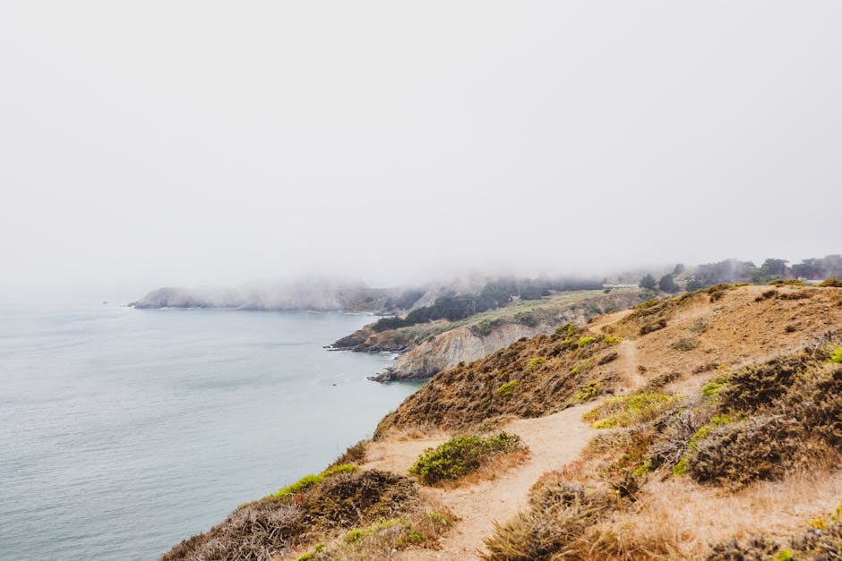
Quick Geography
The Lost Coast spans more than 75 miles of steep, surf battered shoreline.
Located in Humboldt and Mendocino Counties, far from urban centers
Part of the greater King Range National Conservation Area
Bordered by forested ridges, black sand beaches, and ever changing tides
Where Civilization Fades
Once you leave nearby towns like Shelter Cove or Whitethorn, paved roads give way to dirt paths, and eventually to the untamed coastline itself. Cell service disappears, trail markers become sparse, and the only sound is the wind and the waves.
Expect total off grid conditions
No commercial development within the core hiking areas
Wilderness permits required not because it’s busy, but because it’s protected
The Lost Coast doesn’t just feel remote it is remote. And for many, that’s the reason to go.
The Trails Less Traveled
The Lost Coast isn’t just remote it’s rugged, raw, and relentlessly beautiful. Hiking here takes planning, preparation, and a hearty respect for nature’s untamed edge.
Primary Routes to Know
Two main areas make up the Lost Coast’s core hiking territory:
King Range National Conservation Area
Covers the northern section, including the most popular route: the Lost Coast Trail (north section). Expect striking black sand beaches and dramatic cliffs.
Sinkyone Wilderness State Park
Forms the southern segment, offering more forested terrain, secluded coves, and fewer crowds. The terrain here often requires more elevation change and route finding.
Key Logistics to Plan Ahead
Before setting out, dial in these essentials:
Permits: Required for overnight use in the King Range. Book early quota limits apply.
Tide Charts: Critical for timing safe passage along tide dependent zones. Sections become impassable during high tide.
Shuttle Planning: The one way nature of most routes means arranging transport in advance. Shuttle services operate sporadically always confirm in season availability.
The Terrain: Wild and Demanding
The variety of landscapes demands physical and mental endurance:
Black Sand Beaches: Beautiful but challenging to walk expect a slow pace.
Steep Cliffs and Loose Trails: Erosion and narrow paths mean careful footwork.
Surf Zones: Ocean waves can cut off entire segments of trail during high tide.
Why It’s Not Your Average Backpacking Trip
Part of the Lost Coast’s allure is also what makes it tough:
No Amenities: No water stations, restrooms, or shelters. It’s just you and the trail.
Backcountry Only: All camping is primitive limited cell service and zero infrastructure.
Exposure to the Elements: From sudden fog to coastal storms, weather can shift fast.
This isn’t a casual stroll it’s a remote trek designed for adventurous souls who are ready for nature on its terms.
What to Pack and Plan For
The Lost Coast doesn’t forgive clumsy prep. You’ll need gear built for wet, remote, no help terrain. Start with waterproof boots that can handle submerged creek crossings and endless sand slog. Your tent? Make sure it includes coastal stakes that won’t yank loose in shifting dunes or high winds. And yes, bear proof food canisters aren’t optional this is black bear country, and hanging food isn’t reliable here.
Pack light, but don’t skimp. Layers matter weather swings fast, sometimes within the hour. Night temps can drop sharply even in July, so think warmth without bulk. A breathable shell, insulated mid layer, and quality sleep system are non negotiable.
Water’s mostly from seasonal streams. Some dry up by late summer, so carry just enough to flex between sources. Filtration is a must carry a solid gravity or pump filter, or you’ll be boiling your way through every liter. Pro tip: always top off early. The next stream may look close on the map, but this terrain likes surprises.
Timing the Seasons

If you’re planning to backpack the Lost Coast, timing matters more here than on most trails. The best window to go is May through October. That’s when rain is minimal and surf conditions are calmer key factors since parts of the trail cut directly along tide sensitive beaches. Mistiming your entry could mean getting stranded between cliffs and crashing surf. In this place, the ocean sets the schedule.
Winter hiking isn’t just a tougher challenge it’s often flat out dangerous. Storm systems slam the coast, trails vanish under waves, and creek crossings become unpredictable. Even experienced hikers stay away during peak storm season.
Tide awareness here isn’t optional it’s survival. Several sections of the Lost Coast Trail are impassable at high tide. Carry a tide chart. Know the windows of safe passage, which can be narrow, just two to three hours around low tide. Time your hiking segments accordingly, and always plan for delays. Waves don’t wait, and there’s no bailout route.
Hiking the Lost Coast is a real wilderness experience, but one that requires precision planning. Nail the timing, respect the ocean, and the coast might let you pass.
Rich in Solitude and Wildlife
Out here, silence isn’t just golden it’s expected. Don’t count on cell service, crowds, or signage. The Lost Coast is about getting off grid in the purest sense. It’s you, your gear, the trail, and the crashing Pacific below sheer cliffs.
And while humans are rare, wildlife thrives. Roosevelt elk roam freely through the meadows. Harbor seals dot the shoreline, often unbothered but ever watchful. In between, you’ll find rugged flora windswept Douglas firs, coastal scrub, and tidepools teeming with life.
For those who hike for the chance encounters, this place quietly delivers. If you’re itching for more places where nature writes its own script, check out Top Wildlife Watching Spots Across California’s Backcountry.
Leave No Trace in 2026
The Lost Coast isn’t just remote it’s fragile. Every footstep counts. As backcountry interest rises, updated Leave No Trace guidelines have come into sharper focus. Stick to durable surfaces, pack out all trash (yes, including biodegradable scraps), and use a trowel to bury human waste at least 6 8 inches deep and 200 feet from water sources. Fires? Strongly discouraged. Opt for portable stoves; driftwood ecosystems depend on untouched debris.
Local conservation groups like the Lost Coast Interpretive Association are putting in the work. They run volunteer clean ups, monitor trail erosion, and advocate for responsible recreation. Donations, trail work days, or even just learning their restoration maps can make any hiker a hands on steward.
What makes this place special is how little it’s been shaped by us. That magic disappears fast if hikers treat it like a theme park. Preserving the Lost Coast takes more than solitude seekers with good intentions it takes thousands of small, deliberate choices. Respect every campsite, every bluff, every tide washed trail. Because once it’s damaged, it doesn’t come back.
Before You Go
Before setting foot on the Lost Coast, know this: preparation isn’t optional. Start with a permit required for overnight trips in the King Range National Conservation Area. These can be reserved via Recreation.gov, but they go fast during peak months, so plan early.
Next up: navigation. Download topographic maps and GPS apps with offline functionality. Services like Gaia GPS or AllTrails Pro let you store trail data locally critical when you’re beyond cell coverage. Tide tables are equally essential; certain stretches are impassable during high tide and can become dangerous fast. NOAA’s site or local ranger stations offer updated tide forecasts.
Weather can turn without warning. Check short range forecasts just before your departure and monitor predicted wind patterns and surf conditions. Conditions change rapidly on this stretch of coast where mountains meet ocean.
Lastly, know who to call namely, the BLM King Range office or Sinkyone Wilderness State Park station. Jot down their contact info before signal fades.
Final tip: this isn’t an Instagram walk or a casual beach stroll. It’s a serious backcountry trek. The Lost Coast rewards the prepared and punishes the careless. Go in committed or don’t go at all.
 Tavien Quenthos is the kind of writer who genuinely cannot publish something without checking it twice. Maybe three times. They came to cali wilderness expeditions through years of hands-on work rather than theory, which means the things they writes about — Cali Wilderness Expeditions, Horizon Headlines, Hidden Gems, among other areas — are things they has actually tested, questioned, and revised opinions on more than once.
That shows in the work. Tavien's pieces tend to go a level deeper than most. Not in a way that becomes unreadable, but in a way that makes you realize you'd been missing something important. They has a habit of finding the detail that everybody else glosses over and making it the center of the story — which sounds simple, but takes a rare combination of curiosity and patience to pull off consistently. The writing never feels rushed. It feels like someone who sat with the subject long enough to actually understand it.
Outside of specific topics, what Tavien cares about most is whether the reader walks away with something useful. Not impressed. Not entertained. Useful. That's a harder bar to clear than it sounds, and they clears it more often than not — which is why readers tend to remember Tavien's articles long after they've forgotten the headline.
Tavien Quenthos is the kind of writer who genuinely cannot publish something without checking it twice. Maybe three times. They came to cali wilderness expeditions through years of hands-on work rather than theory, which means the things they writes about — Cali Wilderness Expeditions, Horizon Headlines, Hidden Gems, among other areas — are things they has actually tested, questioned, and revised opinions on more than once.
That shows in the work. Tavien's pieces tend to go a level deeper than most. Not in a way that becomes unreadable, but in a way that makes you realize you'd been missing something important. They has a habit of finding the detail that everybody else glosses over and making it the center of the story — which sounds simple, but takes a rare combination of curiosity and patience to pull off consistently. The writing never feels rushed. It feels like someone who sat with the subject long enough to actually understand it.
Outside of specific topics, what Tavien cares about most is whether the reader walks away with something useful. Not impressed. Not entertained. Useful. That's a harder bar to clear than it sounds, and they clears it more often than not — which is why readers tend to remember Tavien's articles long after they've forgotten the headline.