Why the High Sierra Still Reigns in 2026
The John Muir Trail set the gold standard for high country trekking granite, glacier cut passes, and miles of hardly touched wilderness. But the High Sierra isn’t standing still. As the appetite for raw nature surges post pandemic, the region is adapting fast to modern wilderness demand. What’s held steady: the uncompromising terrain, sky high passes, and alpine basins iced in thin air. What’s shifting: how hikers access it, and who’s showing up geared to handle it.
Elevation swings above 10,000 feet and exposed ridgelines still weed out half prepared foot traffic. These loops aren’t beginner friendly, and they don’t try to be. That’s the draw. Veteran hikers aren’t here for cell service or creature comforts they come for the grind, the solitude, and the ecosystems that make hiking here feel closer to mountaineering than strolling.
Permits are still tight, especially during peak months. Trailhead quotas haven’t loosened, and likely won’t. But online systems are smoother. Rolling lotteries, cancellation windows, and third party planner tools are making access a bit more manageable if you plan early and stay flexible. Walk ups? Still possible. But don’t bet your trip on it.
The High Sierra doesn’t bend to trends. It just keeps delivering the wild, mile after mile. The challenge is showing up ready.
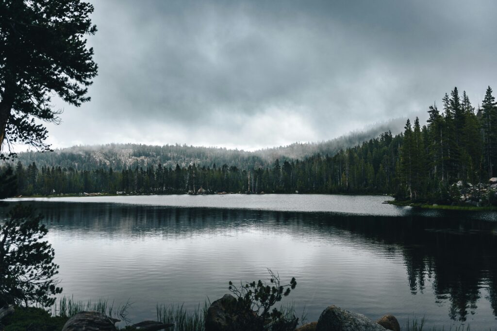
Top Loop #1: Rae Lakes Loop
Distance wise, you’re looking at 41 miles with about 7,000 feet of elevation gain. It’s a solid effort, but manageable for most reasonably fit hikers with a few nights to spare. This loop is one of the most popular in the Sierra for a reason: glacier fed lakes, dramatic granite walls, and enough solitude between passes to feel like you’re off grid without being completely alone.
Most people start at Roads End in Kings Canyon National Park, hiking clockwise toward Paradise Valley or counterclockwise toward Bubbs Creek. Both directions have their merits, but clockwise gives you a gentler climb up to Glen Pass on fresher legs.
Late June through early September is your best bet. Earlier than that can mean snow melt crossings and icy passes; later, you risk early storms shutting things down. The trail is well marked and well traveled, but thanks to bear canister rules and permit quotas, it rarely feels overrun.
What makes this loop ideal for intermediate backpackers? It’s the mix. Big mountain scenery without needing to go full on alpine expert. Pocket sized beaches at Rae Lakes for swimming. Thunderous waterfalls. Even the chance to sleep beside a glacier carved lake basin. You get drama without technical chaos.
Plan ahead, respect the altitude gain, and don’t forget to look up sunset over Glen Pass doesn’t disappoint.
Top Loop #2: Evolution Basin + Darwin Bench Circuit
This route is what happens when you take a beloved section of the John Muir Trail and nudge it off grid. The Evolution Basin + Darwin Bench Circuit builds off the familiar flow, but trades crowds for quiet. Tucked away basins, still mirror lakes, and granite backdrops that look straight out of a dream without the train of thru hikers in tow.
Darwin Bench is the real surprise here. It’s not on many maps in detail, and for good reason. The path up isn’t fully maintained. Cairns can be scattered, and you’ll want a map and compass in hand or trust your GPX track religiously. But once you reach the bench, panoramic silence and ribbon like streams make the effort worth it.
Expect long climbs over alpine passes, near perfect stargazing, and rock slides that double as natural playgrounds. Water is everywhere just be ready to scramble for it. It’s not a casual outing, but it’s not Type 3 punishment either. Solid footwork, sound judgment, and some wilderness grit? You’re good to go.
Top Loop #3: North Yosemite High Route

This isn’t a trail. It’s an untamed line across some of the most severe and beautiful terrain in the Sierra. The North Yosemite High Route stitches together faint paths, talus ramps, and alpine passes that regularly crack 10,000 feet. Expect no signage, no switchbacks, and absolutely no margin for poor planning.
The mileage floats around 70, but it fluctuates depending on which passes you target and where you start. Entry and exit points like Twin Lakes, Tuolumne Meadows, or even remote points along the Sierra High Route can shape your version of the loop. No matter how you slice it, you’ll hit massive elevation gain, technical footing, and long stretches between reliable water sources.
What makes it epic? The high angle granite basins that stretch for miles. Views that punch you in the chest. Silence so deep it hums. There’s no crowd here. There’s no casual. This is type 2 fun at high altitude.
Only attempt this loop if you’ve logged serious time in the backcountry. That means strong route finding skills, physical conditioning, and a detailed plan that accounts for weather, exits, and resupply (if you’re doing an extended itinerary). In short: know your limit then train past it.
Gear Considerations for Sierra Loops
The High Sierra doesn’t babysit, and your gear should reflect that. Bear canisters are still non negotiable in most zones. Rangers check, and bears don’t care how careful you think you are with your food hang.
Weather swings fast up high. One hour it’s sunshine and stillness, the next it’s hypothermia in a storm territory. Go ultralight if you like, but layer smart base, mid, shell and assume every evening will surprise you.
Footwear isn’t about fashion. Ditch the gore tex unless it’s early season and wet. What you need is traction for granite slabs, dusty switchbacks, and creek crossings that don’t announce themselves. Grip beats waterproof every time.
Last, bring the filter. That alpine snowmelt may look crisp and pure, but it’s not microbe free. Giardia still lurks, even at 11,000 feet. Clean water is non negotiable if you want to keep moving.
Keep it light, reliable, and real. The range rewards those who prep, not those who hope.
Packing in the Permits and Prep Work
Getting into the High Sierra isn’t like rolling up to a Saturday hike. With trailhead quotas enforced across nearly every major loop, especially during peak season (late June to early September), scoring a permit takes strategy. Log on early, know your entry and exit points, and stay flexible with dates. Better yet, look to shoulder seasons June and late September not just to beat the quotas, but to enjoy emptier trails and quieter camps.
There’s also the altitude. Much of the Sierra sits above 9,000 feet, and if you’re not ready, it’ll hit you hard. Give yourself a day or two to acclimate before heading into the high stuff. Simple rule: don’t go straight from sea level to slogging up Glen Pass with a 35 pound pack. Camp low on night one, hike high, sleep low where possible. Drink water like it’s your part time job.
Then there’s etiquette no one wants to follow up a majestic view with a trashed camp or a poorly buried waste mound. Leave No Trace isn’t a suggestion here; it’s the unspoken code. That means packing out every wrapper, digging catholes 6 8 inches deep and at least 200 feet from trails and water, and resisting the urge to build that Instagrammable rock cairn. The goal is simple: make it seem like you were never there.
Looking Beyond the High Sierra
Sometimes, you hit trail fatigue. Maybe it’s the altitude. Maybe it’s the endless switchbacks carved into granite. Either way, not every trip has to be a summit mission. When your legs want something gentler and your mind craves salt air over scree, head to the coast.
California’s coastal wilderness trails offer a different kind of awe lush forests giving way to cliffside views, ocean mist hanging in the morning air, and trails that wind through redwoods, over bluffs, and down to quiet coves. These aren’t casual boardwalk strolls, either. Many of these trails are rugged, remote, and wild in their own right.
Some of the best routes thread through places like Big Sur’s Ventana Wilderness, the Lost Coast in northern Mendocino, or even remote sections of Point Reyes during foggy off seasons. You’ll trade alpine passes for tide charts and sunrises over roaring waves.
Not sure where to start? Check out A Guide to Coastal Wilderness Trails in California for detailed routes and tips on timing, logistics, and trail safety.
The Sierra might offer big sky and high drama, but the coast brings rhythm, reflection, and a whole different kind of wilderness intimacy.
Final Trail Thoughts
A Landscape That Rewards and Humbles
The High Sierra is more than a wilderness destination it’s an experience that tests endurance, sharpens outdoor skill, and offers unmatched alpine beauty in return. Whether traversing granite passes or camping beneath starlit skies, these trails remind you just how small and alive you can feel in the mountains.
Sudden storms, loose scree, and high elevation demand preparation
Alpine lakes, sweeping ridgelines, and glacier sculpted basins deliver lasting memories
Why 2026 is a Peak Year for These Loops
As access evolves and technology continues to shape backcountry travel, the core value of immersive wilderness hasn’t changed. These loops continue to set the standard for challenging, awe inspiring excursions in California’s wildest region.
Permit systems may change, but trail quality remains high
Community knowledge, gear innovation, and conservation awareness make 2026 an ideal time to explore
Final Take
From Rae Lakes to the North Yosemite High Route, these backpacking loops aren’t just treks they’re milestones. If you’re ready for clear air, long climbs, and deep solitude, the High Sierra is waiting.
Be prepared. Go with reverence. And know that every summit carries a story only the wilderness can help you write.
 Ask Josephine Raybandett how they got into horizon headlines and you'll probably get a longer answer than you expected. The short version: Josephine started doing it, got genuinely hooked, and at some point realized they had accumulated enough hard-won knowledge that it would be a waste not to share it. So they started writing.
What makes Josephine worth reading is that they skips the obvious stuff. Nobody needs another surface-level take on Horizon Headlines, Adventure Gear Essentials, Outdoor Exploration Basics. What readers actually want is the nuance — the part that only becomes clear after you've made a few mistakes and figured out why. That's the territory Josephine operates in. The writing is direct, occasionally blunt, and always built around what's actually true rather than what sounds good in an article. They has little patience for filler, which means they's pieces tend to be denser with real information than the average post on the same subject.
Josephine doesn't write to impress anyone. They writes because they has things to say that they genuinely thinks people should hear. That motivation — basic as it sounds — produces something noticeably different from content written for clicks or word count. Readers pick up on it. The comments on Josephine's work tend to reflect that.
Ask Josephine Raybandett how they got into horizon headlines and you'll probably get a longer answer than you expected. The short version: Josephine started doing it, got genuinely hooked, and at some point realized they had accumulated enough hard-won knowledge that it would be a waste not to share it. So they started writing.
What makes Josephine worth reading is that they skips the obvious stuff. Nobody needs another surface-level take on Horizon Headlines, Adventure Gear Essentials, Outdoor Exploration Basics. What readers actually want is the nuance — the part that only becomes clear after you've made a few mistakes and figured out why. That's the territory Josephine operates in. The writing is direct, occasionally blunt, and always built around what's actually true rather than what sounds good in an article. They has little patience for filler, which means they's pieces tend to be denser with real information than the average post on the same subject.
Josephine doesn't write to impress anyone. They writes because they has things to say that they genuinely thinks people should hear. That motivation — basic as it sounds — produces something noticeably different from content written for clicks or word count. Readers pick up on it. The comments on Josephine's work tend to reflect that.